For the third straight night, thousands of people in Chicago's north and northwestern suburbs have no electricty. The effects of Thursday's two belts of storms are still quite apparent for them.
And of course the area rivers are near or just past flood level. Earlier today I took a run--with my digital camera in hand--along the Chicago River North Branch Trail.
Damaging flooding from the Chicago River is rare--excess water can be diverted by the North Shore Channel and the Chicago River locks in downtown Chicago. Besides, the Cook County Forest Preserve District owns much of the land on both sides of the river, so trees and shrubs, instead of homes, take the brunt of any flooding.

However, this Niles resident isn't taking any chances. The owner of this bungalow has sandbags ready in case more rain comes.

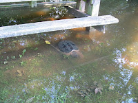
And the water is pretty close to that house; across Harts Road is this partially submerged picnic table. And yes, that is a very large turtle just below the water's surface.
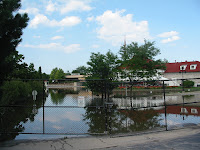
That's not to say that the North Branch has only effected trees and plants near its banks. On the right is the entrance of the closed-for-now Tam Golf Course.

And I had to alter my running route this afternoon. The part of the trail in the bottom picture is underwater, cyclists can stuggle through it, but I just didn't want to run through ankle deep water, so I turned around.

Technorati tags:
No comments:
Post a Comment